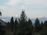
Mountain climb graph
Nov
13


I feel tired just looking at it.
| S | M | T | W | Th | F | S |
|---|---|---|---|---|---|---|
| 1 | 2 | 3 | 4 | 5 | 6 | 7 |
| 8 | 9 | 10 | 11 | 12 | 13 | 14 |
| 15 | 16 | 17 | 18 | 19 | 20 | 21 |
| 22 | 23 | 24 | 25 | 26 | 27 | 28 |
| 29 | 30 | 31 |
 エメラルド
エメラルド
Posted at 2012-11-15 21:36
People Who Wowed This Post